PCT Winter Traverse

False Summits...My first winter in the Sierra
Thursday, February 5, 2015
Pass. Valley. Pass. Valley. That has been our mantra for the last 450 miles. The transition from hiking to snowshoes to skiing has been one of adaptation and flexibility. It feels as if as soon as a routine is solidified, it is uprooted by another mode of travel or a change in weather patterns. Morning routines feel clunky at first with all of the added ski and avi gear. Estimating daily mileage is rudimentary at best and the worry of what lies ahead is always present. We’ve been through a lot at this point, which is both comforting and exhausting. Even now, to sit here at Walker Pass, mile 2000, with the shadow of the High Sierra behind us, I am in awe. It is February 5th, day 108, and we are still moving south.
I’ve intentionally put off writing this update until I experienced the entire High Sierra. For one, not to jinx expectations and two, not to have any in the first place. Sometimes its just better to keep rolling when the times are good. We could not have asked for a better weather window for the 25-days we spent traversing south on skis. The recent weather reports hitting the headlines seem like we made it out just in time. Up to 10” of water content is expected to hit central and northern California in the next week. We need it, to say the least.
But it is not to say that weather alone makes for a silky smooth experience. It is only a matter of time until someone udders the phrase “Well, they only made it through because it was a low snow year”. I’m not a betting man, but I’ll put $5 on that. Let me speak from experience and say that sometimes more snow is easier. Having come through the High Sierra on skis twice now through lower than average snowpack, the transitions are what eat up time and add to frustration.
Snowpack is a fickle thing. Too soft and you’re slogging, too firm and its not edge-able. If you’re planning on heading into the High Sierra anytime soon these are the conditions you’ll likely see. Snow is deepest in the valley bottoms. We saw only 2-3’, at most, of base in some of the upper basins. South facing aspects are totally burned off, even up to 11,000+ft. There is a thin crust layer with endless sugary facets below. If the basin has been wind effected, the crust layer is generally firm enough to support and expedite travel. We saw very little signs of instability, but things will get spicy quickly with any new snowpack than builds atop the current faceted conditions. I’d consider myself an expert at this point of survival skiing through the variable conditions and linking turns via rock hopping. My ski bases are proof of that, at least the learning curve aspect.
It is odd to me how skiing has such a reputation for ease and efficiency in winter travel. Granted I will gladly ski any day over snowshoeing, but some of the most menial tasks become ones of difficulty and frustration. All of that glitter is not gold; crossing open water, filling water bottles at water sources, transitioning from rock to snow, even climbing and descending through sticky or faceted snow is sometimes one step forward, one giant step back. Trauma can attest to my hoarse voice and creative use of the english language on some of the simplest of climbs. I’ll use the abbreviation GDBFC to express my most common of phrases. I’ll let your imagination do what it wants with what that means.
I’ve been getting a lot of questions surrounding what our route and resupply strategy was going to be through the High SIerra. To summarize: Pass. Valley. Pass. Valley. For the highest segments of our route, minimizing the drop into the valley portion was a key ingredient. The PCT loves to contour and anyone with any ski experience can attest to how inefficient it is to contour on skis, especially if you are on firm ice and windboard. Starting from Tahoe we opted for the much more direct Mosquito Pass over Dick’s through Desolation Wilderness. Sonora Pass is closed for the winter making resupply near impossible. We were fortunate enough to arrange for a drop at the Mountain Warfare Center in Pickel Meadows, which necessitated a more creative route to the east to make that a ski-thru resupply. Heading into Yosemite we opted for a higher and more direct route via Kirkwood, Buckeye, Mule and Burro Pass placing us under the shadow of Matterhorn Peak; a route I would highly recommend to anyone to avoid the roller coaster the PCT takes through there.
South of Mammoth we went into some of my favorite basins in the entire range. After descending Silver Pass we went up Mono Creek and linked in the seldom done Sierra High Route via Second Recess and over 12,000’ Gabbot Pass. Despite the sunny weather, we could see the snow spooling off of the upper peaks all day. Gabbot Pass is the only place I’ve been literally blown off my feet. I’ve never been a good gauge of estimating wind velocity, but whatever speed it takes to lift a 165lb man and leave them in the fetal position getting sandblasted by snow granules, it was at least that strong that day.
Lake Italy, Granite Park, Royce Lakes, Humphrey’s Basin; all stunning terrain. Alpine Col linked us back into the PCT with an ascent that felt more like ski mountaineering. Scrambling through car sized boulders, pulling low 5th class moves with skis strapped to your back is, um, awkward. A storm from the south brought 1-3” of fresh snow over Muir Pass, but wasn’t enough to coat the lower elevations, and in fact was just enough to cover any exposed rocks, creating core-shot land mines for the rest of the trip.
Mather, Pinchot, Glen and Forester all had their own variety in descent. Mather was a 1000’ face of dust on bullet hard, barely edge-able ice. Pinchot was a mish-mash of rock and skiable traversing, descending directly off the pass, as the trail proper was completely blown in and steep. Glen was one of our biggest worries and the site of Orland Bartholomew's infamous avalanche in his 1929 ski of the John Muir Trail. We found ourselves a top Glen Pass looking down on mostly snow-free switchbacks. The only pass we weren’t able to link any turns down, leaving a feeling of relief and disappointment.
We arranged with a friend for a food cache atop Kearsarge Pass which meant a bittersweet balance of no town time in Independence and the efficiency of 250mi and 12 days straight through the High Sierra. Forester Pass, the highest point on the entire trail, lay only to our south; the metaphorical last challenge for the remainder of the trip. White out conditions that day further fueled our anxiety. We discussed possible alternates over Junction Pass or the ski mountaineering route over the Great Western Divide, but the familiarity of Forester and the lower than average conditions won over our confidence. There tends to be a trend of whenever we surmount a high point along the trail, there is bound to be foul weather. Our photo on Forester together is very reminiscent of the OR/WA high point we took two months earlier; snowy but smiling. The descent was over before we knew it. The cornice commonly seen early season by north-bounders was barely curling 2ft. The steep switchbacks leading off the pass were filled in but edge-able, leaving only the chute. The upper portion had similar conditions to Mather, dust on steep, barely edge-able ice transitioning into boney talus. We clung along the far edge of the chute to get purchase in the snow and ice by heal plunging the rest of the chute. The switchbacks the trail takes to the chute were far too filled in and exposed to consider a viable option. A few woot’s and sighs of relief left less than 100mi to Walker Pass.
Its amazing how fast the transition from ski to desert goes through the Southern Sierra. It was almost too much to comprehend as I found myself skiing through the sage, feeling the first bout of post-Sierra blues. For how much I cursed my skis at times, I was already starting to miss them. By the time we were carrying them for miles on our packs through sunny 60F degree days, the lust was over. Get these things off of me.
With less than 50 miles into things to come, we can already tell the next bout of challenges will be dry, dry waterless stretches. Already some of the commonly flowing sources have been found dust and parched. The juxtaposition of wintery alpine and endless water to shorts and several 30+mi waterless stretches continue the trend of never knowing what lie ahead. The false summit is ever present at mile 2000. My chance of success has risen to 92%, but the winter PCT will not go down without a final fight.
See you all at the border.
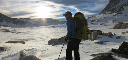
Morning sunrise through the Royce Lakes Basin. A high(er) than PCT route was needed through the High Sierra to maximize ski efficiency. Higher effort tends to yield higher reward. We found it by getting off the beaten path.


